There is a Harriet Tubman Underground Trail you can follow. It's not really underground! It's 125 miles of various wildlife and historic sites.
Here's what you can do if you want to bike part of it:
First, get a booklet with all the stops:
I downloaded this one for free on-line. I think if you go to http://www.harriettubmanbyway.org/ you can find the same one or maybe an updated version.
The part that I biked was this little bit around Preston and Harmony, two little towns on the Eastern Shore of Maryland. The landscape is very beautiful, and the roads are pretty rural, and with wide shoulders, so you should be fine on a bike. If you bike in and amongst these six very interesting landmarks, I think it's about 15 or 20 miles.

First, I biked along Dover Bridge Road towards Preston. I started from across the river in Talbot County, so I had to cross the bridge over the blue river. The bridge has no shoulder for a bike. So I waited at the bridge until the coast was clear from cars, and then sped across as fast as I could. I biked in the very center of the lane, so that if a car did come up from behind they wouldn't try to pass me. They'd just have to be a tiny bit patient.
You get to Preston, and you can take a break, buy water or something from the stores. When you're ready, keep on the main road, and keep biking until you are on the other side of the town. The main road all of a sudden becomes a big highway. That's okay, just keep going a little bit more.
Landmark 17: an old Quaker house
Keep going until you see Seaman Road. It will be on the left. Since you are biking on the right shoulder, you have to cross the lanes of traffic. It's okay, though: this highway was pretty empty on the Saturday or Sunday I did this in September. Wait until the coast is clear, and cross.
Seaman Road is very rural, it's just a bunch of houses, and there's actually no marker that gives you any instructions about the Quaker House. I biked and biked, and felt I must have gone too far, so then I doubled back. I paid close attention, and finally saw a mailbox that looked like this:

See the little circular tag staked into the ground? That is the marker for the Harriet Tubman Underground Trail. BUT, this is a private house, so you can't actually go in!
This is what the Quaker House (landmark 17) looks like from the road.

There is information about this Quaker House in the guidebook: I think it sounds really cool!

Landmark 18: Linchester Mill
Bike on Seaman Road back towards the highway; on the highway, turn back towards Preston, and soon enough the highway will again just be plain old Main Street. You just have a little bit of bike to do before you see a lane parallel to Main Street. It's called Linchester Road, and it is landmark 18. This little road is amazing!
Not only is there the mill, but there is also an old school, an old house, an old post office, and pictures. It is beautifully restored and so colorful, it makes you happy and cheerful just to look at it all! It's like an old little town!
Here is the school, the store, the post office ...

Across the way is the mill:

The mill is from the 1600s or something; and it was the mill that stayed in service the longest, until the 1970s or 80s or something, after all the other mills in the US went out of business. And, when you go inside, there is a short film about the mill made by Charles Kuralt, the great journalist from North Carolina.
I think I was there on a Sunday, and the mill and the other buildings were supposed to be closed. But, the carpenter restoring everything was around, so every time people drove up, he gave us tours of the mill, and let us walk around the houses.
Here is his dog, who was also around:

They are short on funds (the Caroline County Historical Society) so they restore and improve as they can. I think that the carpenter, whose name I think was Michael MacCready, offers a lot of his services for free. The whole project is really, really amazing, and the mill was sooooo so beautiful inside:

You can go up onto the third floor of the mill: it's like you've climbed Jack's beanstalk to the Heavens!
The carpenter is still restoring things, but there are helpful signs everywhere so you don't get hurt. I think he said that the wood in the mill is from the original forests 400 years ago, or something, and he said something about the wood being so special that it doesn't rot, or something!

The mill inside is all like in this picture: shadows, good wood smells, unexpected peepholes and nooks and holes everywhere. It was like being in a dream! And, as to the historical aspect, you can find mill technology inside it that spans 4 centuries: you can see the earliest mill technology, and then how it advanced during the 1700s and 1800s.

Mill technology
They had pictures of the last man to run the mill. I think he was in his 80s, and still working.

Once you leave the mill, you should check out the house, the school and the post office.
The carpenter told me a great story about who had owned the house and an old lady who had stayed on and on. I think I wrote it down somewhere, I just need to find it!
A quaint staircase:

An old old book. I think this was a schoolbook from the 1800s. I found it in the big bedroom of the house, which they had furnished with an old bed, bedspread, books, and clothes. The carpenter knew all sorts of things about it, like which room was the nursery and how the furniture was arranged and on and on.

The carpenter said that after they restore the house, they want to turn the top floor into a residency for a writer. I think that would be amazing for a lucky someone!
Outside of the schoolhouse, I found this picture:

I don't remember the exact year, but I think these children must have grown up and be dead by now.
Now, consult your map again...

... and it's time to be off to landmark 20. I definitely wanted to see the site of Harriet Tubman's most daring rescues.
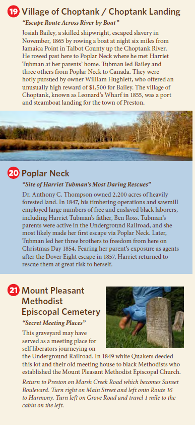
Landmark 20: Poplar Neck
Biking from Linchester Mill to Poplar Neck was pretty long. I left Linchester Road and got back onto the main road; biked back through Preston, and had my eye out for Marsh Creek Road. After biking a while on Marsh Creek Road, you swing onto Poplar Neck Road. These roads are very empty. I biked and biked and biked, but I didn't see any historical markers or anything.
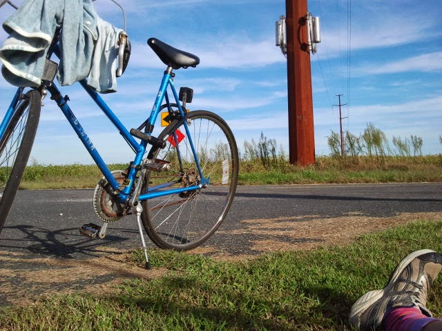
By the time you get to the end of Poplar Neck Road, you are surrounded by trees, through which you from time to time see the water. It is so very very empty of people that it kind of made me nervous:

Although it seems as though I put aside my nerves and made time for a photo-shoot.
So I had not found landmark 20, but looking at the map, I could see the thin grey line that was the road from Landmark 20 to Landmark 19. Even though it was not highlighted in orange, I decided it was definitely the closest and speediest way to go. So I kept going, even when there were big orange signs saying ROAD CLOSED and even when the road became a dirt road, and even when it became wet and thick with orange, viscous mud, and even when everything was so still and quiet that I was certain an ax-murderer must be hiding amongst the trees. I kept going until I came to the place where the thin grey road crosses the river, and that was where I saw the bridge was broken. So I had to turn back after all. So now you know!
In summary, to get from Landmark 20 to Landmark 19, you have to go all the way back up Poplar Neck Road, turn onto a connecting road, and then take a right onto Maple Avenue, which leads to Choptank Road.
Landmark 21: Mt. Pleasant Methodist Episcopal Cemetery
On the connecting road, you reach Landmark 21. I was probably tired by now, so I biked along the road without catching sight of this cemetery. I didn't go back to try to find it, either. So make sure you keep your eyes open if you don't want to miss it!
Landmark 19: Village of Choptank/Choptank Landing
Having missed Landmark 20 and 21, I finally reached Landmark 19. This one is hard to miss because it is an entire little village:


It was beautiful! A very small village, though I think it had a post office, and lots of views like this.
Landmark 20: Poplar Neck
And guess what, while in that village, I found the "site of Harriet Tubman's most daring rescues" which I had missed on the wild wanderings:

So Landmark 20 is really over at Landmark 19!
And because I wanted to be very thorough, I biked onto the complementary end of the thin grey road, and indeed, I again came to ROAD CLOSED signs:

Now I just had to get up to Landmark 22, which was the home that a freed slave built:
Bike all the way back up Choptank Road. At the point where it turns into Maple Avenue, you can stop and rest, because it is so beautiful!!!
Keep biking onto Maple Avenue and continue into Preston. Just keep going straight onto Harmony Road/Highway 16, and keep going and keep going until you turn left onto Grove Road. This area is all full of fields and forests, but there are a few houses here and there, and a few cars. I don't exactly remember how wide the shoulders were, but it's okay, because there's so few cars. Keep your eyes peeled, because the freed slave house is really small and easy to miss. It will be on your left!
Landmark 22: Webb Cabin
This place is so cute and sweet!


There was a whole story about how the escaped slave built it by hand (I think the carpenter told me that one, too). You can walk around and see the garden, and if you go around the back of the house, there is a door so you can go inside. I think there was just a fireplace; and I think there was a loft.
So concludes that little section of the Harriet Tubman Underground Trail. The roads are all nice and flat, so no hill will daunt you; and the area is far enough inland from the Chesapeake Bay that rough winds won't harm you.
If you want to complete the circle and get back to Dover Bridge Road, just continue on Grove Road until it ends; take a left on Bethlehem Road, and you will be back at Dover Bridge Road before your aching feet can thank you.
But! if you go the other direction on Bethlehem Road you will end up in Harmony. Somewhere around there is a park with the most fun and wild-swinging swing-set I've been on.
If you go onto the official website, they have a page with all the dozens of historical landmarks. The trail is new, and I think they must still be organizing it. Thus, the way the landmarks are numbered on the website is different from how they were numbered in my map.
Happy biking!
No comments:
Post a Comment